
Buffalo Bayou meanders into Houston from the West and it curls around the downtown. It starts somewhere from a small spring and gathers itself together as a drainage ditch for the coastal plains that gradually sink into the Gulf of Mexico. The Allen Brothers who laid out the town and sold property in what is now Houston had high praise for the "waterway" passage to the Gulf of Mexico but actually any passage on Buffalo Bayou from the Gulf of Mexico to the new town was difficult even for boats with a shallow draft. Texans think big and so started the "Houston Ship Channel Project." Just to the East of downtown Buffalo Bayou was dredged, and dredged some more and the Bayou became The Houston Ship Channel and we now have the Port of Houston which is the second or third largest port in the USA depending on what you count as tonnage.
Although there are early accounts of people fishing and picnicing on the banks of Buffalo Bayou, in recent years it has been polluted even above the ship channel and it has been widened and dredged to control flooding and bridges have been built across it. Still it has managed to survive and in most places to the West of Houston, trees and vines grow along its edge. But at times after a flood the trees are festuned with plastic bags and debris. As it curled around town it was overgrown and the homeless set up camps under the bridges.
A group of Houstonians wanted more from Buffalo Bayou. Maybe because they saw the attraction that a River has been made into in San Antonio and so a 20 year project has been underway to "beautify" the bayou. I have mixed feelings about this project. I'd like to see the debris kept out of the trees but for me the wilderness aspect of this waterway has always been charming. I photographed along its banks just West of downtown from the Sabine Street Bridge to the Waugh Street Bridge. I liked walking along its banks tangled with vines and into tunnels under the bridges or through trees. I never stopped being astonished by suddenly seeing the city skyline as I came around a thicket of trees.
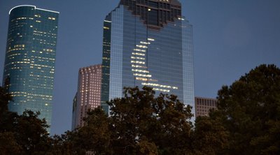 The first phase of this project was opened last weekend with a celebration called Blue Bayou. From the Sabine Street Bridge to Bagby, the waterway has been landscaped, lighted, walks improved and a pedestrian bridge has been added. The lighting will change colors with the phases of the moon. It is all very nice but I hope that the next phase going West doesn't change the wilderness character of Buffalo Bayou too much.
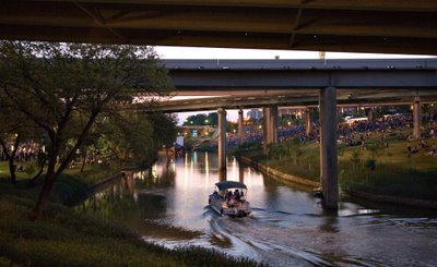
I don't know if these photographs are too dark or not. It was dusk but I'm working on a laptop and the slightest tilt of the screen changes the density.


4 comments:
the pics look good. I really liked Houston and want to go back someday. enjoyed these pics and background.
There is great value in places retaining their character.
Leigh
It continues to amaze me that people just can't leave well enough alone. Make Houston into San Antonia....sigh. They are trying to make Worcester into Providence AND San Antonio. There is an old canal that is currently underground and they want to displace about 40 merchants and turn the street into a river (it's only a creek) walk at the cost of about $100 million. Who thinks up these things?
Pitchertaker
Billie, it was great running into you and Ned at the Blue Bayou Festival! That's a great picture of the building with the crescent moon on it (I used to work in that building).
Billoh
Post a Comment